Winter Preview: Monday Night into Tuesday is Cold
As rain showers taper off Monday evening, a sharp cold front will usher in much colder air across Connecticut. Temperatures will fall quickly from west to east, with overnight lows plunging into the mid to upper 20s—even along the shoreline. A Freeze Warning is in effect for coastal areas, [...]
High Wind Alert: What to Expect Wednesday Night into Thursday Morning
We have a WIND ALERT as we head into the middle of the week. The latest data this morning is showing an aggressive setup for a high wind event starting tomorrow evening as a cold front moves through the region, and and lasting through Thursday morning. For a few [...]
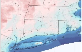
FREEZE WARNING IN EFFECT MONDAY MORNING FOR CT
A Freeze Warning is in effect from 1 AM to 9 AM EDT Monday for parts of the region. Temperatures are expected to drop as low as 30°F, especially in outlying and low-lying areas. These conditions pose a risk to sensitive vegetation, which may suffer damage or be killed [...]

Comet C/2025 A6 (Lemmon) Nears Closest Approach
Southington, CT — Stargazers across Connecticut were treated to a spectacular celestial display last night as Comet C/2025 A6 (Lemmon) made a brilliant appearance in the night sky. Thanks to local astrophotographer Gary Grindle (@garygrindle on X), a stunning image captured from Southington showcases the comet glowing brightly near [...]
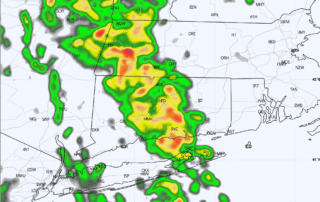
Brief Line of Heavy Weather Monday Morning
A period of rain and gusty winds will move through early tomorrow morning as a cold front comes into the area. Briefly heavy rainfall and wind gusts 30 to 40 mph are the hazards. Parts of our area have also been highlighted in a 2% to 4% Tornado Risk [...]
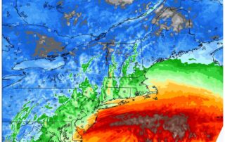
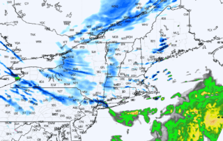
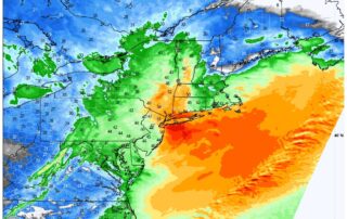
COASTAL STORM UPDATE: Nor’easter To Impact Southern New England
Evening data is in and I see no major changes with the storm. Short range guidance has started coming within range as well, which helps us gain resolution. HRRR model below. Headlines remain the same: HRRR model showing broad low pressure with periods of rain Monday RAIN: [...]
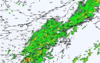
Rainy Start to Wednesday Across Connecticut
Rain is expected to move into the state late tonight and continue through Wednesday morning. The general window for precipitation is 12:00 AM to 12:00 PM Wednesday, with the heaviest rain likely during the morning commute (5:00 AM to 9:00 AM). If you're heading out early, be prepared for [...]