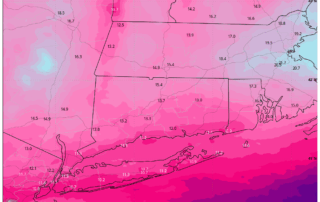
Major Winter Storm on the Way: What to Expect Sunday Into Monday
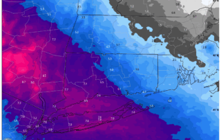
A significant winter storm is setting its sights on our region, and the latest data continues to point toward a high‑impact event from Sunday into Monday. With arctic air already in place and a powerful storm system approaching from the west, all ingredients are aligning for substantial snowfall across [...]
Snow Threats: Breaking down MLK Weekend Storm Potential
There remain 2 periods of winter weather to focus on in the 5-Day Forecast. Both of these could potential give us accumulating snow. The first is Saturday morning through midday when snow showers work in. Watching for a burst of potentially moderate snow before sunrise Saturday that would coat [...]
A Light Icing Tuesday Night into Wednesday
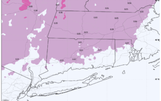
Low pressure will track to the north of our area by tonight. With temperatures falling back near freezing this evening, we will have to watch for some light freezing rain or mixed precipitation across interior zones where a WITER WEATHER ADVISORY has been issued. Given the amount of salt [...]
New Year’s Outlook: Light Snow to Ring In New Year
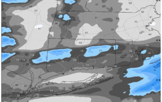
A weak system will approach the area Wednesday night into Thursday morning. A few models track low pressure over the area, with a bit more enhanced snowfall. A general coating to an inch is expected, primarily between 12AM and 5AM on Thursday. Some of the short range guidance such [...]
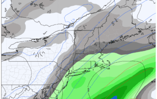
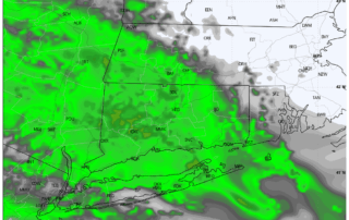
Winter Storm Warning Issued for Western Connecticut and Hudson Valley: Snow is Coming
A significant winter storm is set to impact the region Friday night into Saturday morning, prompting the National Weather Service to issue a Winter Storm Warning for Fairfield, New Haven, Litchfield, and Westchester Counties. A Winter Weather Advisory remains in effect for Hartford and Middlesex Counties. Low pressure will [...]
Weather Blog: A Chilly Stretch Ahead
If you’ve been feeling the chill lately, get ready—winter is making its presence known across the region. Dry conditions will dominate through midweek, but temperatures will remain well below normal. Highs Wednesday and Thursday will only reach the upper 30s to lower 40s, about 10 degrees colder than what [...]
Thanksgiving Week Weather: From Mild Showers to Holiday Chill in Southern New England
As Thanksgiving approaches, Southern New England is in for a weather rollercoaster. From mild showers early in the week to a sharp drop in temperatures for the holiday and beyond, here’s what you need to know to plan your celebrations and shopping trips. Forecast Breakdown Monday: Mostly cloudy skies [...]