Connecticut Weather Blog: Clearing Skies Today, Midweek Rain Ahead
A cold front swept through the region overnight, leaving behind a few lingering showers across southeastern Connecticut and Rhode Island early this morning. Those final showers will taper off shortly after sunrise, setting the stage for a gradual return to quieter weather conditions. 🌬️ Today: Clearing and Comfortable Behind [...]
Sunshine Early, Showers Later Today — Wetter Saturday Ahead Before a Better Mother’s Day
Good morning! We’re starting the day on a bright note across the region, with morning satellite imagery showing mostly sunny skies. A seasonably cool air mass has settled in overnight, and many local weather stations dropped into the lower and middle 40s by sunrise — definitely a crisp start [...]
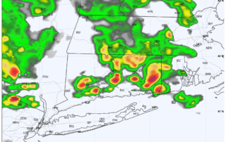
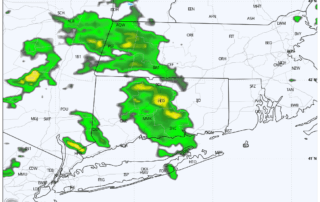
Thunderstorms Possible Wednesday Evening into Wednesday Night
After a generally quiet but hot day, the threat for showers and thunderstorms increases late tonight, as a subtle change in the upper‑air pattern moves across the region. Between roughly 9 PM and 3 AM, a shortwave passing north of the area may provide enough lift to interact with [...]
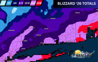
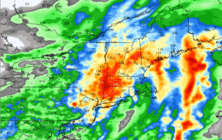
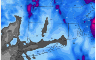
Breaking Down the Blizzard of 2026: Why Snow Totals Varied So Dramatically
In the aftermath of the Blizzard of 2026, many people asked for a more regional breakdown of snowfall totals—and understandably so. This storm delivered a complex combination of classic coastal development and intense mesoscale banding that created sharp gradients over short distances. Here’s a closer look at what happened. [...]
Weekend Weather Breakdown: Snow, Wind & Brutal Cold Ahead
Happy Friday! 😎 Here’s what to expect as we head into a very active stretch of winter weather across the region. 1. Increasing Clouds Today Clouds will thicken through the day as our next system approaches. High temperatures will stay cold—generally in the upper 20s to low 30s across [...]
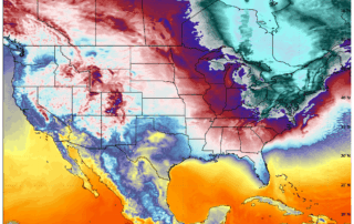
Brace for Dangerously Cold Air This Weekend: What to Expect
After a stretch of quiet, seasonably cold weather, conditions across the region are about to take a sharp and potentially dangerous turn. While Thursday and Friday begin on a calm note, a fast‑moving clipper system arriving Friday night will open the door to the coldest air mass of the [...]
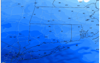
Winter Storm Update: High Confidence in Heavy Snowfall, Sleet Line Still a Wildcard
Our latest evening data continues to support a high‑impact winter storm for the entire region from Sunday into Monday. Confidence remains very high that this will be a heavy snow event, with widespread plowable to disruptive snowfall. At this point, the only meaningful variable still left to resolve is [...]