Late this week, an infamous “Omega Block” weather pattern will be settling in across the United States.
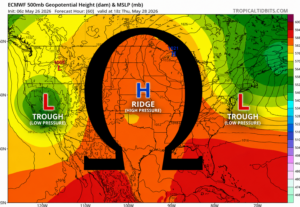
The Greek letter Ω mapped over the ECMWF 500mb forecast for Thursday, May 28
The idea of the omega block is that the positioning of areas of high and low pressure create an arrangement of troughing and ridging that ultimately resembles the Greek letter omega Ω. Here is a simple breakdown of the puzzle pieces here:
- At its core, an omega block is all about the “block” directly over the central United States due to the presence of a strong high-pressure system, creating ridging in the upper-level wind pattern.
- With the presence of the high-pressure system, two areas of low pressure settle over the two coasts. These systems are accompanied by troughing, leading to southward dips in the upper-level wind pattern.
- Together, the upper-level wind is driven below the west coast trough, up and over the central ridge, and back down south along the east coast, roughly tracing the shape of the Greek letter omega Ω.
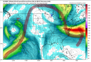
A rough drawing of the overarching jet stream (upper level) wind pattern illustrated over the ECMWF 250mb wind forecast for Thursday, May 28
So, what does this “omega block” mean for us?
Unfortunately, the omega block isn’t usually a good sign for New England. Notice how the wind that reaches New England originates out of Canada? This means that in this setup, we’ll have a steady supply of crisp, cool Canadian air. I know that’s exactly what you wanted to hear.
On the bright side, this doesn’t mean every day will be brutally cold. Since we’re nearly into June at this point, the powerful influence of the sun will still allow us to warm up on the drier days, and we’ll actually enjoy some very comfortable days. The thing we will be seeing a lot of, however, is cold-cored disturbances. These storm systems will contain anomalously cold air in the upper and middle levels of the atmosphere. When precipitation is falling, it will allow this cold air to drop down to the surface and prevent the sunlight from combatting it. This upcoming weekend will feature miserable conditions due to one of these disturbances.
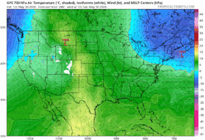
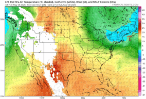
Temperatures at two distinct levels in the atmosphere from the gfs model for Saturday, May 30. 700mb (mid-levels of the atmosphere) left, and 850 mb (low levels of the atmosphere) right.
These maps really tell the story of how the cold air aloft (high up) provided by the omega block setup, leads to cold weather for us on the ground. On the 700mb map, notice the deep blue blob (yuck) positioned over the Northeast. See the empty, or white, tiles near the Rocky Mountains? This map is showing us that at the same height in the atmosphere as the highest peaks in the United States over our heads, the air will be well below freezing. On the 850mb map, notice how much area is blocked out. That means the 850mb height is so low in the atmosphere that a lot of our continent is actually elevated above this level. Effectively, this is a few thousand feet over our heads. Here, we can see temperatures are still below freezing by a bit (where the blue meets the green is the freezing line), even though they aren’t far above our heads. With such cold air so low above our heads, falling precipitation, which will begin as snow high up before melting a couple thousand feet over our heads, will bring down that fantastic cold air we just haven’t had enough of this month, with more temperatures in the 40’s and 50’s this weekend!
High elevation snow in the White Mountains of New Hampshire cannot be ruled out!
Yeah, the Omega Block may not be so great for us. And yeah, it is possible to have a worse weather weekend than we just had. But hey, at least there’s no holiday to ruin this time around!