
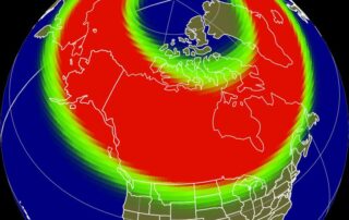
Aurora Possible Tonight (G2 Watch)
Once again, we have a shot at seeing the aurora tonight. The sun erupted again on Wednesday, producing a modest C6.7 flare. While the flare strength was very weak, especially compared to the M and X class flares over the last week and a half, the eruption had a [...]
Severe Weather Likely to End the Week
The second half of this week is bringing an unusual three-day severe weather stretch to our area. The National Weather Service Storm Prediction Center has highlighted the potential for severe weather with a level 1/5 marginal risk today in some areas, and level 2/5 slight risks for tomorrow and [...]
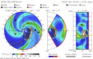
Aurora Redemption Tonight? (G3 Watch June 8)
The sun has erupted once again! This time, a relatively simple (not complex) region produced an explosion of plasma with an M1.8 moderate intensity solar flare. The eruptions the other day were produced by a complex active region of sunspots, with three large solar flares, reaching M9.3, M7.8, and [...]
Aurora Possible Tonight, G3 Watch (6/4)
The sun has erupted in a massive way over the last 48 hours! A complex active region of sunspots on the sun has erupted in a series of three large solar flares, reaching M9.3, M7.8, and X1.1 on the solar flare x-ray scale. M is the second greatest level, [...]
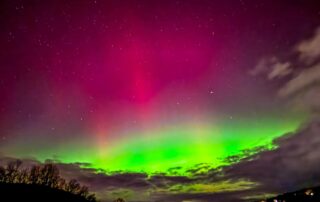
My Ultimate Aurora Chasing Guide
This (unofficial) statistic may surprise you: We have Aurora 5-10+ times a year. That doesn’t include the 2-3+ times it’s there and blocked by clouds. At the end of last summer, I became a serious aurora chaser. Since the beginning of last September, I’ve captured 12 auroras. That includes [...]
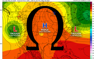
An “Omega Block” May Lead to an Extended Period of Cool Weather
Late this week, an infamous "Omega Block" weather pattern will be settling in across the United States. The Greek letter Ω mapped over the ECMWF 500mb forecast for Thursday, May 28 The idea of the omega block is that the positioning of areas of high and low pressure [...]