Our latest evening data continues to support a high‑impact winter storm for the entire region from Sunday into Monday. Confidence remains very high that this will be a heavy snow event, with widespread plowable to disruptive snowfall. At this point, the only meaningful variable still left to resolve is how far north sleet manages to push on Sunday night.
Let’s break down what we know — and what we’re still watching.
Heavy Snow Remains Likely for the Entire Region
Across all guidance, the signals for heavy snow remain strong. The question isn’t if we get significant accumulation — it’s simply where totals fall within the range.
- If sleet mixes in earlier Sunday night, totals will land on the lower end.
- If the storm stays all snow, especially across southern zones, then totals will be on the higher end, with the potential for some localized over‑performance.
Either way, impacts look significant.
Updated Snowfall Expectations
Based on ensemble guidance:
- Factoring in the very cold airmass and high snow‑to‑liquid ratios, totals could reach 10 to 16 inches.
- The far northwest hills remain favored for the highest totals, where sleet intrusion is unlikely and the dry slot will have less influence. Somewhere in NW or NW CT could see 18+ inches!
Localized higher amounts are still on the table if the storm’s track remains ideal.
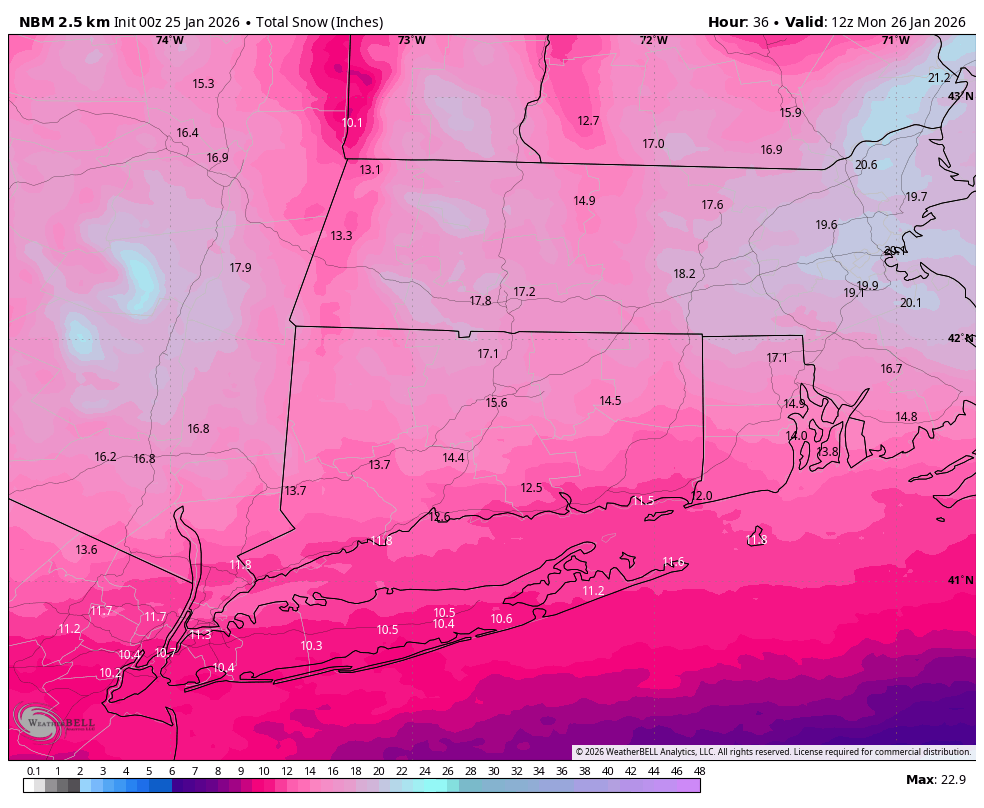
NBM Snow Totals
Chance for Thundersnow
One notable addition tonight:
There is now a non‑zero chance for thundersnow, especially during the period of strongest lift Sunday evening.
The combination of deep moisture transport, strong atmospheric instability aloft, and intense banding potential increases the likelihood of convective snow bursts. If thundersnow develops, snowfall rates could reach 2 to 3 inches per hour, quickly boosting totals in those bands.

HRRR Future Radar 12PM
Sleet Line Still the Wildcard
Warm air creeping in aloft Sunday night remains the primary uncertainty. Temperatures may briefly nudge into the 20s, creating just enough warmth above the surface to introduce sleet in the storm’s dry slot.
However, even in a scenario where sleet mixes in:
- The region would already have 10 inches or more on the ground before the transition begins.
- Impacts remain largely unchanged — travel will still be hazardous and snowfall totals will stay significant.


