With the area as dry as a tinder box, any rain would be helpful. I usually wouldn’t do this level of analysis on a few showers, but we need the rain so desperately.
Low-level moisture will continue to increase on Tuesday with a SE wind off the Atlantic Ocean. This will lead to a lot of clouds through the day, and the possibility of drizzle or light showers towards the afternoon and evening. Later in the day, energy from a wave coming through the Great Lakes will also reach the area, providing some lift and enhancing the shower potential across the interior.
The “drizzle” setup during the day can be seen here on the HRRR, with the SE wind direction off the water converging more with a SSW wind over New York and New Jersey.

The reason I am less confident in any soaking rain from this is an abundance of dry air in the column. These charts can look confusing, but essentially where the green dew point line and the red temperature line separate (from about 800mb to 500mb) there is just a lot of dry air. A PWAT (Precipitable Water) of 0.75 inches doesn’t add a ton of confidence either. This chart is valid for mid Tuesday afternoon.

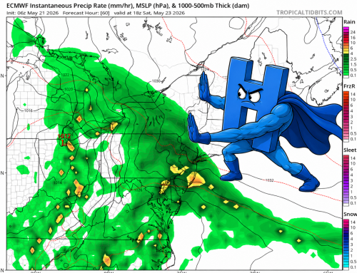
Given this setup, the most likely precipitation size would be very fine liquid water droplets or drizzle. As mid level energy approaches this evening, some additional showers will work into the area. These will also be moisture starved and generally light in nature. The European model spits out a general 0.05 to 0.10 inches of rain. See below.

Generally for this amount of rain I would just put “a few showers” in the forecast and call it a day. Unfortunately, 10/7 was the last time we saw rainfall of even this magnitude, so I feel every opportunity to help our deficit needs ample analysis. There is another slight chance of showers Friday, but the overall pattern continues to be very dry.
Oh – and its going to be 80 degrees for Halloween!