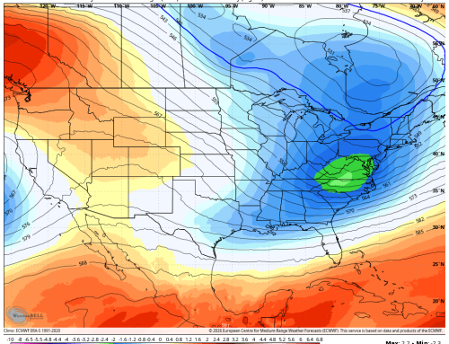
A shift in the upper-level weather pattern is bringing a noticeable change to our local conditions. As the upper trough exits eastern Canada and ridging builds along the East Coast, temperatures will rise into the 80s early this week, accompanied by mild overnight lows in the 60s.
🔥 Wildfire Smoke & Air Quality Concerns
Smoke from Canadian wildfires is expected to drift southward into the region late Sunday into Monday. While visibility impacts are expected to be minimal, hazy skies will be noticeable, and air quality alerts may be issued due to elevated near-surface smoke concentrations. The latest HRRR guidance suggests smoke levels could meet alert criteria, prompting a moderate to high risk for poor air quality on Monday.
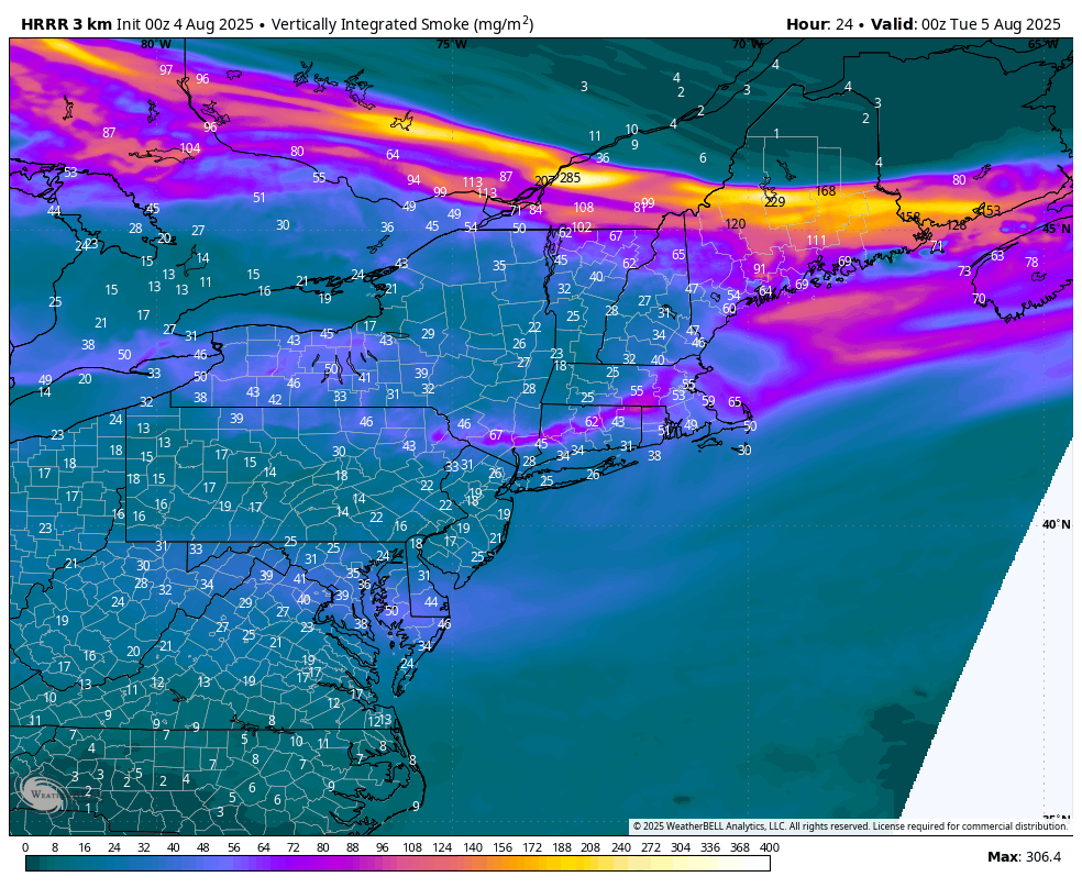
HRRR Smoke 8PM Monday
🌡️ 36-Hour Forecast
Today (Monday):
☀️ Mostly sunny and hazy with elevated wildfire smoke.
🌡️ Highs: Mid to upper 80s
💨 Winds: North 5–10 mph
Tonight:
🌙 Mostly clear
🌡️ Lows: Mid to upper 60s
💨 Light winds
Tomorrow (Tuesday):
☀️ Mostly sunny with a chance of a stray afternoon shower or storm.
🌡️ Highs: Mid to upper 80s
💨 Winds: East 5–10 mph
🚨 24-Hour Alert Summary
| Threat Type | Level |
|---|---|
| River Flooding | 0 |
| Urban/Poor Drainage Flooding | 0 |
| Fire Danger | 0 |
| Poor Air Quality/Smoke | 4 |
| Fog | 0 |
| Damaging Winds/Power Outages | 0 |
| Thunderstorms | 0 |
| Excessive Heat/Humidity | 0 |
| Hail | 0 |
| Tornadoes | 0 |
📅 Extended Forecast: August 6–10
- Wednesday: Partly sunny with isolated afternoon showers/storms. Highs in the low to mid 80s.
- Thursday–Friday: Mostly sunny and dry. Highs in the low to mid 80s.
- Saturday–Sunday: Mostly sunny and warmer. Highs in the mid to upper 80s.
🧭 Outlook Summary
Expect a stretch of pleasant and stable weather through the weekend, with seasonable temperatures and gradually increasing humidity—but nothing too uncomfortable. Keep an eye on air quality alerts Monday due to wildfire smoke, and enjoy the calm conditions ahead!