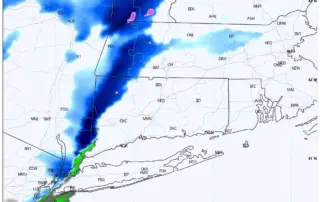
SNOW SQUALLS SUNDAY 1-14-24
Models are continuing to be bullish on snow squall potential tomorrow. It appears these squalls will be traversing the area between 12PM and 4PM along an arctic front. Temperatures in the mid to upper 30s around noon will drop quickly to the upper 20s or low 30s as the [...]
STORM UPDATE: PREPARE FOR HIGH WINDS AND HEAVY RAIN
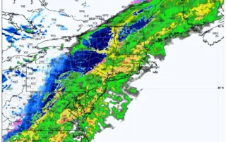
Forecast is on track for a big ticket “Southeaster” to impact the area tonight and tomorrow. This storm has already produced widespread rain and wind impacts in the Southeast and the Carolinas today, and will come chugging up the coast tonight. Expecting 2.0 to 4.0 inches of rain, with [...]
Another Sunday Night Soaker: Rain and Wind Expected Sunday Night into Monday
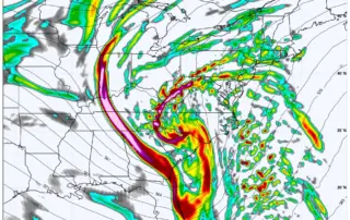
It feels like déjà vu! Another large storm is on the way late Sunday into Monday - and it will not be snow. Despite another rain event, this is an interesting setup from a meteorological perspective, with a trough dipping down well into the Gulf of Mexico, interacting with [...]
UPDATE: Latest Briefing on the Multi-Hazard Storm Set for Sunday Into Monday
We have just briefed our clients and local Emergency Managers on the storm system impacting the region tonight through Monday. As of now, no changes to the thinking. The forecast is on track. The damaging wind risk will mostly relegated to Eastern CT, with flooding being the largest threat [...]
STORM UPDATE: Multiple Hazards Coming for the Forecast Region
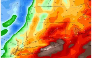
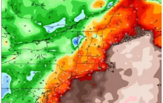
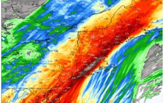
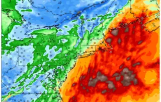
1. WINDS: Based on current forecast, peak wind gusts 35 mph to 45 mph in the Hudson Valley, Western CT and Central CT; 45 mph to 55 mph in Eastern CT, and 50 mph to 65 mph in coastal New London County and Rhode Island. 2. RAIN: Models continue [...]
Potent Storm Approaches Sunday Night
All attention in the Weather Center has turned to a robust and potent storm system that will be moving through Sunday afternoon to Monday. The likelihood of rain increases as the afternoon goes on Sunday, with rain and wind strongest for about a 12-hour period 7PM Sunday evening through [...]