Discussion: No major changes to the forecast this morning with the only adjustments being to increase the forecast wind gusts slightly and the general storm timing up by a few hours. Debby will track to the west of the area through the day today. Forecast rainfall totals remain 1 to 3 inches for the region through Saturday morning. The WPC continues to maintain a 15% chance of flash flooding in NW CT and only a 5% chance of flash flooding elsewhere. Drizzle, intermittent showers, and an increasing breeze will be the featured weather for Friday.
Winds will continue to increase Friday afternoon, with maximum gusts forecasts increasing to 35 to 45 mph inland and 40 to 50 mph at the shoreline. A WIND ADVISORY has been issued for all coastal CT. Prepare for scattered power outages across the area. The peak of the winds will be approximately 12PM to 10PM Friday. The rain intensity will increase in the evening as well and may outlast the wind in many areas, with peak rainfall rates between approximately 6PM Friday and 4AM Saturday. In addition to the rain and the non-thunderstorm wind threat, any convection that does occur within the warm and unstable quadrant of the storm will be capable of rotating. The SPC has placed most of the region in a 2% to 4% risk of tornadoes within 25 miles of a point, with the Hudson Valley in tornado risk increased to 5% to 9%. As with most tornadoes associated with tropical systems, these will likely be brief and lower on the EF scale. (EF0 and EF1)
Timing: Impacts from Debby will increase on Friday and last through early Saturday morning, with the worst of the storm from 12PM Friday to 2AM Saturday.
Impacts: We are continuing to monitor the potential for excessive rainfall and flash flooding, as well as the threat for Nor’easter type wind gusts and a few spin-up tornadoes. Please continue to monitor this forecast and look out for an update tomorrow morning. Hazard summary includes:
- 1 to 3 inches of rainfall with locally higher amounts possible. This may lead to isolated to scattered incidents of flooding.
- 35 to 45 mph wind gusts inland; 40 to 50 mph wind gusts at the shoreline. This may lead to scattered power outages given the saturated ground.
- Convective thunderstorms that could contain locally gusty winds and the possibility for brief, spin-up tornadoes (Generally EF0 or EF1)
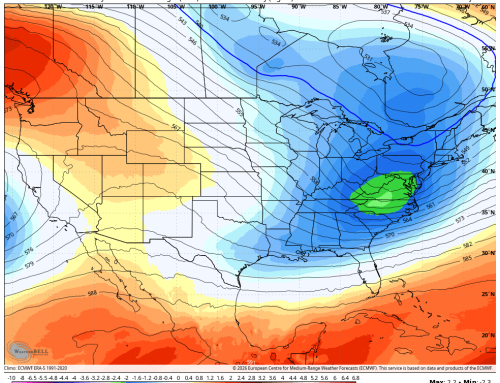
Graphics:
Total Rainfall on Friday morning European model:

Wind Gust Swath (MPH)