Winter Preview: Monday Night into Tuesday is Cold
As rain showers taper off Monday evening, a sharp cold front will usher in much colder air across Connecticut. Temperatures will fall quickly from west to east, with overnight lows plunging into the mid to upper 20s—even along the shoreline. A Freeze Warning is in effect for coastal areas, [...]

What Made Last Night’s Sunset So Epic?
If you were outside last night across Connecticut, you may have noticed the sky glowing with an incredible orange hue long after the sun had dipped below the horizon. It wasn’t just a typical sunset—it was the result of a perfect combination of atmospheric conditions. To the west, a [...]
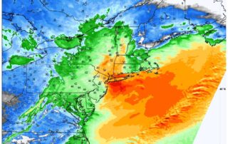
High Wind Alert: What to Expect Wednesday Night into Thursday Morning
We have a WIND ALERT as we head into the middle of the week. The latest data this morning is showing an aggressive setup for a high wind event starting tomorrow evening as a cold front moves through the region, and and lasting through Thursday morning. For a few [...]
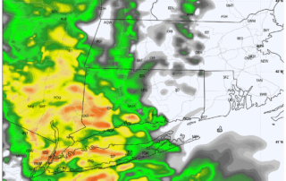
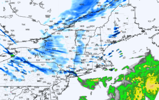
Stormy Thursday Ahead: Rain, Wind & Halloween Outlook
Light showers and drizzle are making their way through the region this morning, accompanied by an increasing easterly breeze. Expect this light rain to continue intermittently through midday. Heavy rainfall into Western and Central CT by 4PM - HRRR future radar By afternoon, conditions will intensify as [...]
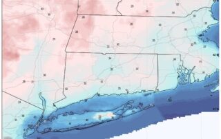
FREEZE WARNING IN EFFECT MONDAY MORNING FOR CT
A Freeze Warning is in effect from 1 AM to 9 AM EDT Monday for parts of the region. Temperatures are expected to drop as low as 30°F, especially in outlying and low-lying areas. These conditions pose a risk to sensitive vegetation, which may suffer damage or be killed [...]
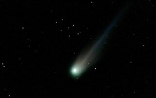
Comet C/2025 A6 (Lemmon) Nears Closest Approach
Southington, CT — Stargazers across Connecticut were treated to a spectacular celestial display last night as Comet C/2025 A6 (Lemmon) made a brilliant appearance in the night sky. Thanks to local astrophotographer Gary Grindle (@garygrindle on X), a stunning image captured from Southington showcases the comet glowing brightly near [...]