After a stretch of heat, humidity, and storms, Connecticut is finally getting a well-deserved break. A cold front moved through the region Sunday, and a second reinforcing front is expected to pass through Monday afternoon or evening. Behind it, a cooler and much drier air mass will settle in, bringing some of the most comfortable weather we’ve seen in weeks.
Cooler, Breezy, and Comfortable
Monday will feel like a breath of fresh air. Expect mostly sunny skies, a refreshing northwest breeze gusting up to 25 mph, and high temperatures in the upper 70s to low 80s—slightly below average for late July. Dew points will drop into the 40s and low 50s, making it feel crisp and pleasant, especially compared to the muggy conditions we’ve recently endured.
Monday night will be clear and cool. With light winds and low humidity, temperatures will dip into the upper 40s in the northwest hills and rural areas, with low 60s in urban centers. It’s a perfect night to open the windows and give the air conditioning a break.
More Beautiful Weather Tuesday
Tuesday continues the trend of sunny skies and low humidity. Highs will again reach the upper 70s to low 80s, and dew points will remain comfortably low. Tuesday night may be even cooler than Monday night, with widespread 50s and some upper 40s possible in the usual cold spots.
Warming Up Midweek
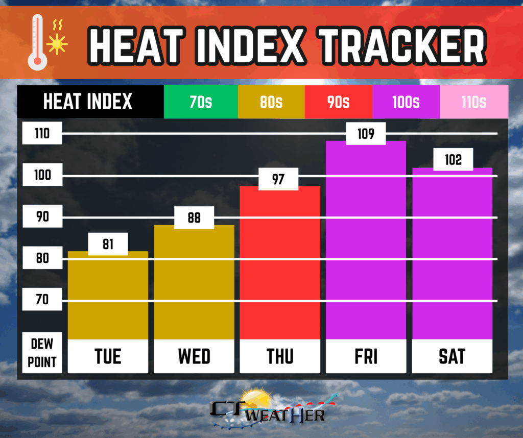
By Wednesday, high pressure will shift offshore and a ridge will build over the eastern U.S., allowing temperatures to climb. Highs will reach the mid to upper 80s, and humidity will begin to increase. Thursday will be warmer and more humid, with heat index values approaching 95°F in parts of the state.
Above average temperatures creep back into the picture by the end of the week.
Heat and Storms Return by Friday
Friday is shaping up to be the hottest day of the week. High temperatures could soar into the 90s, and with high humidity, heat index values may exceed 100°F—possibly reaching 105°F in some areas. Heat advisories or even warnings may be issued. A cold front will approach late in the day, bringing a chance for scattered showers and thunderstorms, some of which could be strong.
The front may stall near or just south of the region on Saturday, keeping the chance for additional showers and storms in the forecast. Sunday’s outlook is still uncertain, but drier air may return depending on the position of the front.
Bottom Line: Enjoy the cool, dry weather while it lasts—Connecticut’s next heat wave is just around the corner. Stay hydrated, stay informed, and be prepared for changing conditions as we head into the weekend.