
A Few Sprinkles Do Little to Quell Brush Fire Concerns
Dry conditions have fire crews remaining busy across CT with the ongoing brush fire threat. Yesterday, Connecticut Army National Guard helicopters responded to the ongoing 100+ acre brush fire in Berlin, CT, near Lamentation Mountain. The scene is unlike anything typically seen in the state, as one UH-60 Blackhawk, [...]

RED FLAG WARNING ISSUED: Hot and Dry Conditions Fuel CT Fires
TUESDAY EVENING UPDATE: A rare autumn RED FLAG WARNING is in effect 8AM to 7PM Wednesday for all of Connecticut. Several large brush fires have been reported through CT the last several days. A combination of strong winds, low elative humidity, and dry fuels will create a significantly elevated [...]

Temperatures Rise for a Beautiful Fall Weekend
October is often a month of change in Connecticut. This year, October has featured daily highs that are at or slightly above normal. Overnight lows, however, have been a touch cooler than usual. This pattern is largely due to the abundance of dry air and clear skies, allowing daytime [...]

Comet Visible in Western Sky at Dusk
NOTABLE SKY EVENT. If we get some clearing this evening to the west, look to spot the Comet 2023 A3 Atlas just above the Western horizon. Best viewing should be around 7:00PM to 7:30PM, or approximately 45 minutes after sunset. The comet was first discovered in 2023 and will be [...]
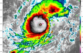
Hurricane Milton: Category 5 Storm Heads Towards Florida
Rapid Intensification and Current Status Hurricane Milton has rapidly intensified over the past 24 hours, transforming into a powerful Category 5 hurricane just northwest of the Yucatán Peninsula. This small but potent storm now boasts wind speeds of 180 mph and a central pressure of 905 mb, making it [...]

Everything to Know About Crepuscular Rays
If you want a fun word to throw around the office, the light phenomenon many observed this afternoon was a vivid display of “Crepuscular” rays. Crepuscular has always sounded like some sort of medical anatomy term to me, but these rays are beaming. Photo shared from Keith A [...]

What is the ‘Flash Flood Emergency’ Alert?
One of my big takeaways from this forecast and talking to people afterwards has been the confusion betweeen Flash Flood Warning and Flash Flood Emergency. Any time you see the term “Emergency” in a weather alert it’s a really big deal whether it’s for flooding or god forbid a [...]