In the aftermath of the Blizzard of 2026, many people asked for a more regional breakdown of snowfall totals—and understandably so. This storm delivered a complex combination of classic coastal development and intense mesoscale banding that created sharp gradients over short distances. Here’s a closer look at what happened.
A Storm Just South of the Benchmark
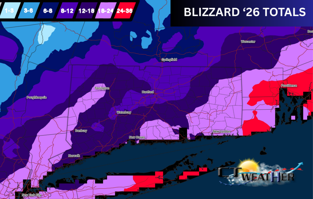
The storm ultimately tracked just south of the well‑known 40/70 benchmark, a location meteorologists often use to anticipate where the heaviest snowfall will occur in major Northeast winter storms. A track slightly south of this point typically favors the highest totals across Long Island, Rhode Island, and eastern Massachusetts.
But this was no ordinary storm.
Despite the southern track, the system’s sheer size and strength set the stage for a powerful deformation band to form farther inland—directly affecting parts of Hudson Valley and central Connecticut. This was the feature that ended up delivering the truly impressive totals.
The Deformation Band: Who Saw the Biggest Snow?
The deformation band—the zone of strongest lift and most intense snowfall—set up from Torrington to New Milford to Danbury and down through the Hudson Valley into New York City. This corridor became the jackpot zone, where snowfall totals exceeded 18 inches in many areas.
These banding features are notoriously fickle, and small shifts can dramatically change where the highest totals land. In this case, the band held remarkably steady for hours, allowing significant accumulations to stack up.
Subsidence Zone: Why the Dip in Totals?
When strong bands of heavy snow develop, there’s often an area in between where air sinks instead of rises. Meteorologists refer to this as subsidence, and it can lead to lower snowfall rates despite a major storm occurring on either side.
This effect showed up clearly from Hartford to Waterbury, where totals were noticeably lower than those seen to the west—yet still impressive. A foot of snow accompanied by 50 mph winds is far from insignificant, but compared to the jackpot zone, it represented the storm’s “valley” of accumulation.
One For the Books
All told, the Blizzard of 2026 will go down as a historic winter event for the region. ’26 will be a storm long remembered by residents, public works crews, meteorologists, and anyone who spent hours digging out afterward.


