The pattern for about the last 6 weeks has been a fairly consistent cycle of high pressures migrating over the area. This has been driven by consistently strong 500mb ridging. Generally “ridging” at the upper levels as seen below will result in warm and dry conditions. In the winter, this type of setup would spell doom for cold and snow lovers, but in late October and November it has brought us pleasant weather if not for the drought and wildfire concerns.

The general idea of what has occurred repeatedly at the surface is this… Seasonable and dry conditions as high pressure sits overhead will slowly transition to warmer and slightly more humid conditions as high pressure migrates to the east over the ocean. Eventually, a moisture-starved cold front will push through, bringing ‘maybe’ a few showers. After that, high pressure will build back in from the west and the cycle repeats itself. Lots of sunshine – lots of warm days! The days we have been seeing record highs is when the high pressure is in its Eastern position, as it will be this Wednesday. Note the high pressure here is centered over Bermuda – this would be a HOT day if it occurred in the summer!

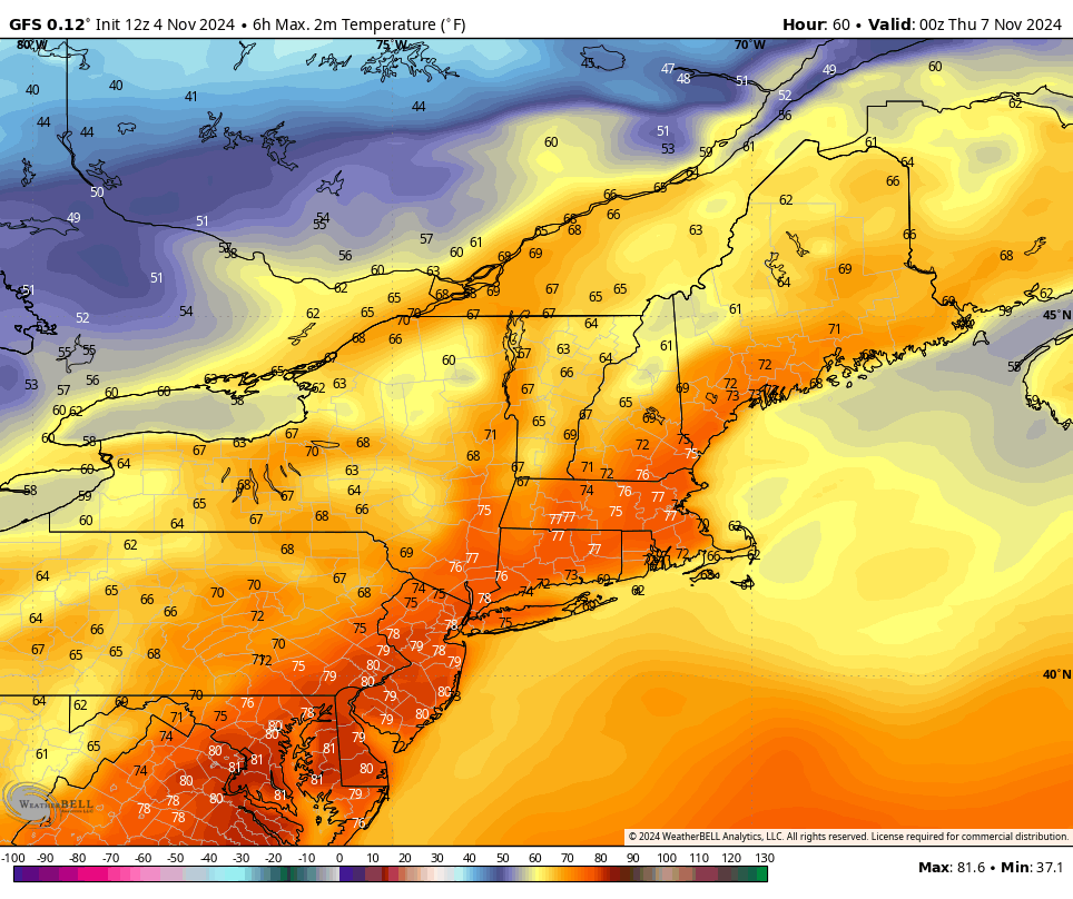
So.. same ole story this week. Look at the high temperatures on the European model on Wednesday. The record high in Bridgeport is 74 (2022) and Danbury is 76 (1938). We will be close to both of these as the current model output mirrors the record highs.
After the record warmth, one of our signature Fall 2024 dry cold fronts will push through Thursday. Windy, cooler, and drier conditions will build in Thursday and Friday will reignite the brush fire risk across CT. I would not be surprised to see additional Red Flag Warnings towards the end of this week. It does look like we may get some steadier showers Sunday.. but that is a blog post for later in the week.
Lastly, and this is just food for thought… IF we get this pattern to flip heading towards late November and early December, it could mean some early snowfall for the area. Stay tuned!