
🌧️ Flood Watch in Effect for Connecticut: What You Need to Know
Issued: Thursday, July 31 | Valid: 2 PM Today – 8 AM Friday A Flood Watch has been issued for our area starting this afternoon and continuing through early Friday morning. If you're in Connecticut, especially in low-lying or flood-prone areas, here's what you need to know to stay safe and [...]

Severe Weather and Extreme Heat Possible Friday in Connecticut
Connecticut is facing a high-impact weather day on Friday, with a combination of dangerous heat and the potential for severe thunderstorms by late afternoon and evening. Extreme Heat First Before storms arrive, the state will endure a brief but intense surge of heat and humidity. Highs will climb into the low to mid-90s, and with [...]
Connecticut Weather Blog: A Muggy Start to the Week with Storms and Heat Ahead
As we head into the new week, Connecticut is in for a stretch of humid, unsettled weather with a few rounds of showers and storms, followed by a potential heat wave midweek. Tonight: Low Clouds and Patchy Fog A weak cold front is slowly approaching from the west, but most of the state [...]
Unsettled July Stretch: Humidity and Storms
Monday (July 7) – Hot, Humid & Breezy Highs: Upper 80s to low 90s (cooler by the shoreline) Feels Like: Low to mid 90s due to high humidity. Conditions: Mostly sunny and breezy with SW winds. Heat Advisory: In effect due to elevated heat index values. Afternoon/Evening: Isolated to scattered showers and thunderstorms [...]
Relief in Sight: Heat Wave Peaks Before Midweek Cool Down
It was BLAZING HOT TODAY ACROSS CT! Many stations reached 95-101 degrees, but relief is on the horizon. A Heat Advisory remains in effect through Wednesday evening, with temperatures once again soaring into the 90s and heat index values climbing as high as 102°F in some areas. While slightly lower [...]
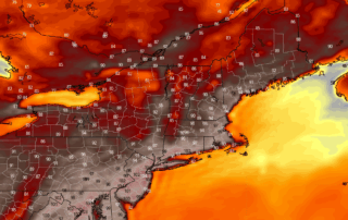
BIG HEAT Coming: Latest Forecast Blog
An intense heat wave will begin today across the NE, with dangerous temperatures and oppressive humidity expected to peak between Monday and Wednesday. An Extreme Heat Warning remains in effect midday Sunday through Tuesday for much of the region, including northeastern New Jersey, the Lower Hudson Valley and much [...]
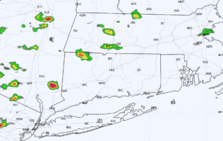
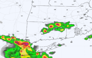
Severe Storms Possible Thursday 06.19.25
Models tonight continue to indicate sufficient instability (~2000j/kg) to go along with sufficient wind shear on Thursday, pointing to the potential for strong to severe storms to work in. Given the environment, damaging wind gusts are the primary concern, with a lower risk for hail and even the potential [...]