A significant winter storm is setting its sights on our region, and the latest data continues to point toward a high‑impact event from Sunday into Monday. With arctic air already in place and a powerful storm system approaching from the west, all ingredients are aligning for substantial snowfall across the area.
Cold Air + Deep Moisture = High Snow Totals
Ahead of the storm, an entrenched arctic airmass will keep temperatures firmly below freezing. As the storm tracks across the country, it will pull in a rich plume of moisture—not just from the Gulf of America, but even the Pacific Ocean, creating an environment primed for heavy snow.
Forecast confidence is notably high at this stage. Most ensemble guidance is currently pointing toward 8 to 12 inches of snowfall, with some projections suggesting 10 to 16 inches once higher snow-to-liquid ratios associated with the cold air are factored in. If the storm follows a more favorable track and any mixing stays to the south, localized higher amounts are certainly possible.
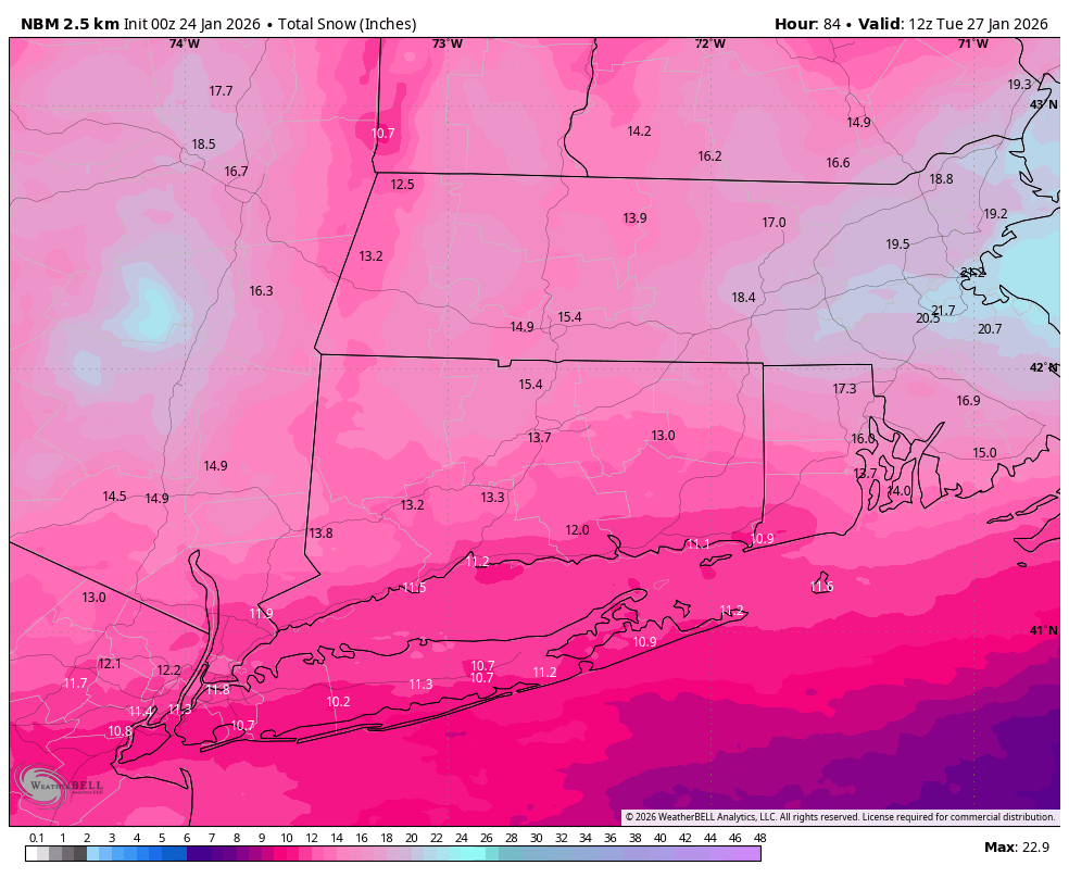
National Blend of Models Snowfall – Initialized 00z 12/24
Watching for Mixing Sunday Night
One factor still being monitored closely is the potential for warm air intrusion aloft Sunday night. Some models show temperatures rising into the 20s, introducing a brief window where mixing or sleet could occur within the storm’s dry slot.
Even if mixing does develop, the region is still likely to receive 10 inches or more of snow before any changeover begins. In other words, the early stages of the storm look overwhelmingly snowy.
Forecast Refinements Ahead
As always, we’ll continue to refine the details as newer, higher‑resolution data becomes available. The storm is still more than a day out, and small track adjustments can influence snowfall totals and the mixing line.
Timing has shifted around a bit, but snow will start around 8AM Sunday, become heavy into Sunday afternoon and early evening, then taper to snow showers by Monday morning.
Stay tuned, stay warm, and get those shovels ready. This one has the potential to be a significant winter weather event for the region.