Issued: Thursday, July 31 | Valid: 2 PM Today – 8 AM Friday
A Flood Watch has been issued for our area starting this afternoon and continuing through early Friday morning. If you’re in Connecticut, especially in low-lying or flood-prone areas, here’s what you need to know to stay safe and prepared.
📍 What’s Happening?
A slow-moving frontal boundary is sagging south through the region and is expected to stall just to our south later today. At the same time, a frontal wave will develop near the Delmarva Peninsula and track eastward, bringing with it a surge of moisture-rich air and instability.
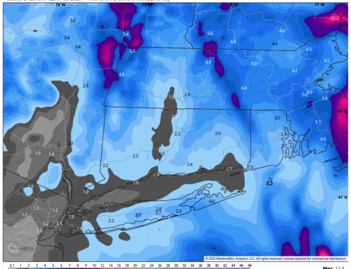
🌧️ Rainfall Forecast
- Widespread rainfall totals of 1.5 to 3 inches are expected.
- Localized amounts could reach up to 5 inches.
- Rainfall rates may exceed 2 inches per hour, especially in southern areas like Long Island and parts of NYC, but Connecticut could still see intense downpours.
⚡ Storm Dynamics
- Instability (MUCAPE values of 1,000–2,000 J/kg) will be higher to the south, but strong wind shear (50–70 kt) across the region means convection is possible anywhere, including Connecticut.
- Tall, skinny CAPE profiles and precipitable water values (PWATs) of 2–2.5 inches suggest highly efficient rainfall processes—meaning storms could dump a lot of rain in a short time.
🌬️ Winds
- A low-level jet (LLJ) of 30–40 kt may enhance winds late Thursday into the night.
- Expect gusts of 25 to 35 mph, especially along the coast and higher elevations.
🕒 Timing
- Heaviest rain is expected between 2 PM and midnight today.
- Rain will taper off from northwest to southeast overnight into early Friday.
- Lingering showers may persist into Friday morning, but the threat of flooding will gradually diminish.
🚨 What You Should Do
- Stay weather-aware: Monitor local alerts and forecasts.
- Avoid flooded roads: “Turn around, don’t drown.”
- Secure outdoor items: Gusty winds could knock things over.
- Prepare for power outages: Especially in areas prone to tree damage.