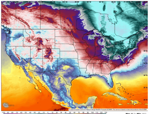
Objectively, the long range outlook as we head into the middle of January is one of the most favorable for potential cold and snowy weather in the Eastern US that I have seen in some time. There’s a lot a major ingredients here that seem to be lining up. The ridging (reds) over British Columbia and Greenland indicate a +PNA and west based -NAO scenario. This is fancy weather speak, but essentially that pattern is highly favorable for polar air move over the United States with storm tracks generally off the coast (nor’easters) instead of over the Great Lakes. This will lead to cold, often snowy, winter storms.
Of course, any long range outlook should be taken with a grain of salt, especially when it comes to details. At this range, there is no way to fully articulate the anatomy of an individual system, and even a cold scenario could result in a storm missing or being shunted south. The European model was basically dry for two weeks on the latest run, as an example. I have always thought it’s fair to say “watch the January 7th through 15th window for winter storms”, but unfair to throw up whatever model has the coldest temperatures and most snow and plead with people to buy extra winter coats.
Unfortunately the latter is often what you get on social media, as posts with more likes, shares, comments will generate the most revenue. In the era of engagement farming, it’s important to understand the source of the information and the motivation an individual will have. For me, it’s always been about accuracy over anything else.
As it sits, it looks like we have a very good chance at a cold, “real winter” stretch coming up for mid January and a decent chance for snow. While a big snow storm may be in the cards as some point, there is certainly no reason to run for bread and milk… at least yet!
We will be here tracking every step of the way.