As we approach the first potential snowfall of the season, I want to give you the latest details. I’ll admit—this trended a bit colder than I originally anticipated. But while there’s some fascinating meteorology to unpack here, I still think this event is a very low to no-impact situation for most areas. However, if you’re a snow enthusiast and live in western Connecticut or parts of New York State, you might have a good chance to catch those first flakes tomorrow morning.
An Unusual Storm Track
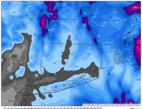
This setup is a peculiar one. A strengthening low-pressure system will move southeast to northwest into Connecticut this evening—a very atypical track for our region. I had difficulty recalling similar storms that produced snow in this way. To the immediate left of the low’s path, strong forcing will create a narrow band of heavy precipitation over southwestern Connecticut and adjacent areas of New York.
As the low passes, a bizarre weather twist unfolds: the “warmer” northerly wind will shift to a “colder” southwesterly wind. It’s not something we see every day, and it’s what makes this storm so intriguing from a meteorological standpoint.
Timing and Snow Potential
Higher elevations may see big, wet snowflakes begin to mix in before midnight, with the changeover happening earlier the farther west you go. Parts of Putnam County and northern Westchester may see snowier conditions compared to areas farther east, and a Winter Weather Advisory is in effect for these regions. Even so, accumulations below 600 feet will likely be limited.
In Connecticut, we could see one of those rare moments where it snows in Greenwich but rains in the Litchfield Hills—an unusual reversal! A mix of rain and snow is expected through daybreak Friday, with more persistent snow likely in New York State and extreme western Connecticut.

Odd looking future radar – HRRR
Accumulation Challenges
While a change to snow looks more probable, several factors will limit accumulations:
- Mild Temperatures: Expect readings between 33 and 36 degrees throughout the event.
- Warm Ground: With today’s rainfall, the ground is far from frozen.
- Surface Conditions: Snow will likely stick only to grassy areas in most locations.

What to Watch
I’ll be eagerly awaiting reports from local spotters, especially in areas like Mahopac, Carmel, and Fishkill, as well as updates from the higher points of Ridgefield, where conditions might get more wintry.
I’ll monitor the situation closely throughout the night and will go live with updates if things take an unexpected turn. Here’s to the first flakes of the season—stay tuned!
– Jack