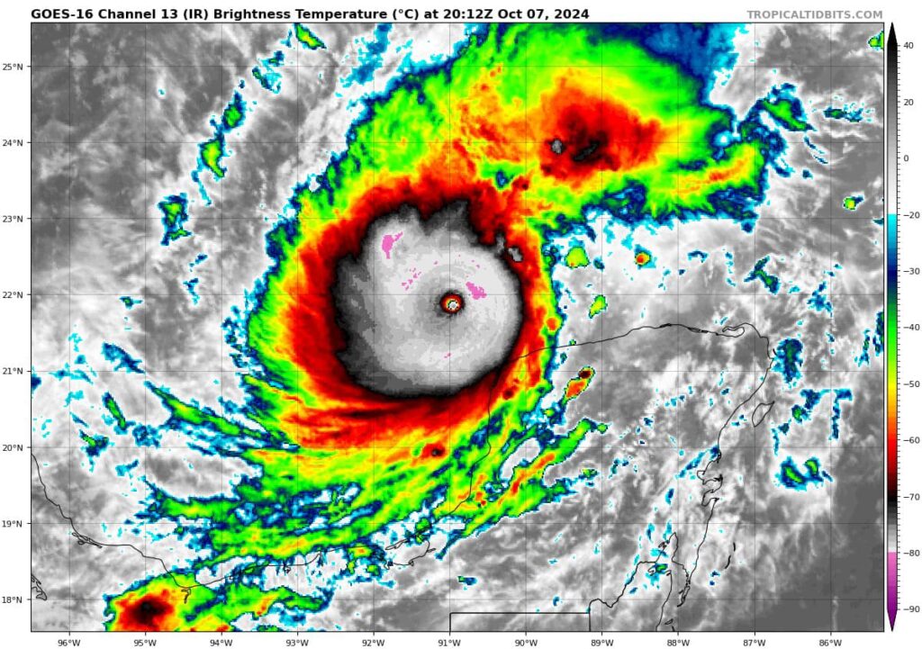
Rapid Intensification and Current Status
Hurricane Milton has rapidly intensified over the past 24 hours, transforming into a powerful Category 5 hurricane just northwest of the Yucatán Peninsula. This small but potent storm now boasts wind speeds of 180 mph and a central pressure of 905 mb, making it a formidable force.
Milton has benefitted from very favorable environmental conditions, including low wind shear, strong upper-level outflow, and warm waters over the last 36 hours. This has allowed the storm to develop a highly symmetric structure, with a well-defined, compact “pinhole” eye at its center—signs of a rapidly intensifying hurricane in the Gulf of Mexico.
The Physics Behind Rapid Intensification
Milton’s quick intensification is not uncommon for small Gulf hurricanes, which tend to spin faster due to their tighter wind radius. This phenomenon is similar to a figure skater spinning faster as they pull their arms in, conserving angular momentum. As the storm grows, this compact core could expand, slowing its winds slightly.
However, this weakening would not necessarily signal a less dangerous storm. As Milton expands, it will affect a larger area, even if the wind speeds drop. This growth will likely be accompanied by Eyewall Replacement Cycles (ERCs), where the storm temporarily weakens before re-strengthening with a broader wind field.
Interaction with the Yucatán Peninsula
Another factor influencing Milton’s intensity in the near term is its proximity to the Yucatán coastline. Although the storm’s core is expected to pass just offshore, some dry air may enter the circulation, potentially weakening the storm slightly. Observations will be key in determining how much, if at all, Milton is impacted.
Path Toward Florida: What to Expect
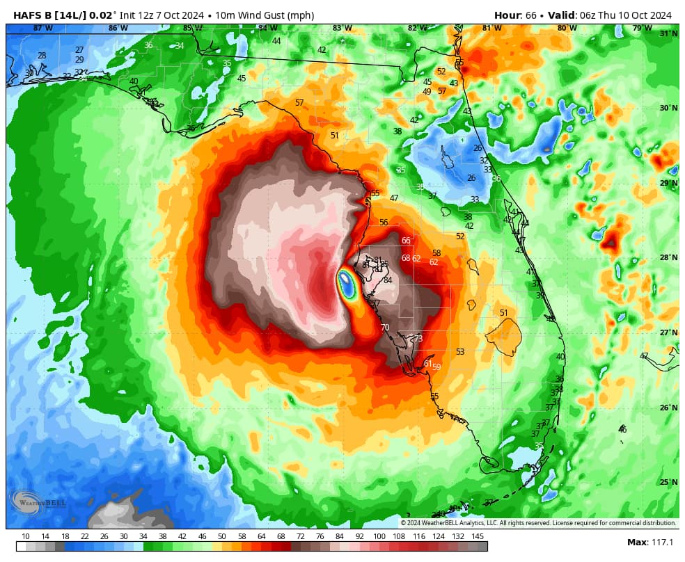
As Milton tracks northeastward, steered by a trough, it will pick up speed and head toward Florida’s west coast. Although the storm is expected to weaken as it encounters less favorable conditions, it could still be a Category 3 hurricane as it approaches Florida. By this point, Milton will likely be larger, with an expanded wind field and the potential to affect a wider area.
Potential Impacts on Florida
Storm Surge
Storm surge is likely to be the most life-threatening aspect of Hurricane Milton. With the current forecast track bringing the center near Tampa, the region is at high risk. The shallow bay, along with the storm’s right front quadrant, could drive water levels 10-15 feet above normal, inundating low-lying areas like Punta Gorda and Port Charlotte.
Wind Damage
Even if Milton weakens to a Category 3, wind damage will be significant, particularly in the right front quadrant of the storm, where the strongest winds will occur. Gusts may reach Category 1 levels far inland, affecting areas like Orlando, Lakeland, and Ocala.
Heavy Rainfall and Flooding
Milton is expected to dump 6-12 inches of rain over a broad swath of Florida, from Tampa to Jacksonville, leading to flash flooding. Flood watches have already been issued in anticipation of this threat.

Conclusion: Preparing for Impact
Hurricane Milton is a dangerous storm with the potential to cause significant damage across Florida. While the storm may weaken, its expanding size and associated hazards—storm surge, high winds, and heavy rain—make it a serious threat. Residents should stay informed and follow all evacuation and safety orders issued by local authorities.


